Abstract
Risk assessment of properties and associated population was conducted for the state of Nebraska, leveraging only open-source datasets. The flood risk framework consisted of interactions among drivers, i.e. hazard, exposure, vulnerability, and response, to assess the risks related to properties and associated populations. To quantify hazard on a county scale, we considered properties at risk of flooding based on a flood score (a higher score represents a greater chance of flooding). Exposure was quantified by considering population density at the county level. We quantified vulnerability under four categories: social, ecological, economic, and health. Response, a relatively newer component in flood risk assessment, was also quantified under three distinct categories: structural, non-structural, and emergency. Overall, we found that counties in eastern Nebraska (Sarpy, Dakota, Wayne, and Adams) have a higher risk of flooding consequences due to more exposure to vulnerable assets such as population and property. The assessment also observed that counties in eastern Nebraska are in the process of improving their flood control measures with dams, levees, and higher insurance coverage that can subdue the risks associated with flooding. The results from this study are anticipated to guide water managers and policymakers in making more effective and locally relevant policies and measures to mitigate flood risks and consequences.
Introduction
According to the Intergovernmental Panel on Climate Change (IPCC) special report on extreme events, the risk associated with disaster can be defined as the likelihood of events that severely alter the normal functioning of a community or society. Specifically, these hazardous, physical events threaten vulnerable peoples’ social conditions1. Risk assessments across the literature prevalently follow the IPCC framework, which quantifies risk as a function of hazard, exposure, and vulnerability2,3,4. However, in a recent study, response was included as a fourth component of risk5. Response refers to the ability to react to a situation and is often excluded as a risk driver. One of the novelties of our study lies in adding a response component to the flood risk framework due to its potential to subdue the adversity of the event.
In the IPCC risk framework, hazard is a function of scale, including the extent and probability of occurrence of a flood event at a given location. Studies have come up with different ways to quantify the hazard associated with flooding, for example, using the Federal Emergency Management Agency’s (FEMA) maps2, flood inundation maps3, climatic projections to account for risk associated with climate change4, and peak discharge for different flood return periods (1000, 100, and 50 years)6. The IPCC defines exposure as the presence of people, livelihood, environmental services and resources, infrastructure, and social and cultural aspects the flooding could adversely affect1. Different factors can account for exposure, such as population density, housing units, impervious surfaces, and elevation and density of infrastructures4. Vulnerability is the propensity or predisposition to be adversely affected by flooding1. To assess vulnerability, studies have considered social dimensions such as age, education, ethnicity, gender, and socioeconomic status2, 4, 7. We classified vulnerability into social, ecological, economic, and health dimensions, considering multiple variables under each section. Our study is unique in that it adds different dimensions to vulnerability and gives insights to quantify response while assessing the risks associated with flooding across Nebraska on a county scale.
Study area, methodology, and datasets information
Study area
Nebraska is a state located in the Midwestern region of the United States. It consists of 93 counties and is surrounded by six states. The topography of Nebraska can be divided into two major land regions – the Dissected Till Plains and the Great Plains (Fig. 1). Dissected Till Plains are located in the eastern part of the state, which consists of rolling hills and fertile agricultural land. This region includes major Nebraska cities – Omaha (Douglas County), Lincoln (Lancaster County), Bellevue (Sarpy County), and Papillion (Sarpy County) (based on existing population). The Great Plains region of Nebraska consists of rolling terrain suitable for agricultural operations. This region is mostly dedicated to corn and wheat fields. The Great Plains of Sand Hills are located in the north-central part of the state, mainly covered with grassy dunes.
Nebraska’s climate and topography play a crucial role when flooding occurs in the state. The Midwestern United States is susceptible to weather patterns, including heavy rainfall, snowstorms, and tornadoes. The region's topography primarily consists of rolling terrain, which makes it even more prone to flooding, as there are no significant natural barriers to counter peak flows. The region also has many major river systems, including the Missouri River, Platte River, and Niobrara River. These rivers and their tributaries drain a large portion of the state and tend to quickly rise and overflow during heavy rain or snowmelt, leading to widespread flooding.
Methodology
The risk assessment of this study aims to understand and quantify the potential dangers posed by flooding in a comprehensive manner, which can help in making more informed decisions related to effective flood management. The multiplication of the components of risk, i.e., hazard, exposure, and vulnerability is a common approach in risk assessment and has been widely reported in the literature3, 4, 7. The multiplication reflects the idea that high exposure to a hazard, combined with high vulnerability, leads to a greater overall risk. Hazard is related to the potential occurrence of a natural or human-induced physical event that can result in loss of life, injury, or other health impacts1. Exposure refers to elements such as population, infrastructures, and natural or artificial resources in an area where hazard events may occur. Vulnerability in literature is defined as the propensity to be adversely affected by a disaster event1.
In this study, we added one more component, i.e. response, which refers to actions and measures taken to reduce risk5. The extent of hazard’s exposure can amplify the risk, especially if that system is highly vulnerable. However, response, in the form of proper actions and measures against flooding, can potentially reduce the risk. In this study, we multiply hazard, exposure, and vulnerability, and divide that outcome by response (as it subdues the risk) to account for the combined effect of drivers on the risk level (Eq. 1).
Equation (1) considers risk as a function of hazard, exposure, vulnerability, and response, and reflects the understanding that all components contribute to the overall level of flood risk. We considered different variables under each driver of risk, which involved different units of measurement or scales. To allow for meaningful comparison and combination, the variables used to quantify the drivers of risk were scaled from 0 to 1 using (Eq. 2)4:
By standardizing the variables, we eliminated the potential bias introduced by the magnitude of the values. We assumed equal importance for each variable within a component. Therefore, the values of each risk driver were combined and divided by the number of drivers used4, resulting in an index ranging from 0 to 1 (Eq. 3):
where D is the driver's index, X.D., i is the ith scaled variable, and n is the number of variables. Averaging the variables under each component simplified the calculation and interpretation of flood risk.
Datasets information
The properties at risk of flood hazard were used as a proxy to quantify the hazard. We obtained this information from the First Street Foundation8 for 2020. The First Street Foundation uses a probabilistic flood model, which considers the hazard associated with rainfall, riverine flooding, and coastal surge flooding. The model identifies property boundaries and then uses elevation data to determine the likelihood of water reaching the premises. The model also considers adding infrastructure protection, including dunes, wetlands, seawalls, and pumps. To quantify hazard, we reviewed properties in Nebraska counties and collected flood factor scores ranging from 1 to 10, where 1 refers to the lowest chance of a property flooding and 10 refers to the highest. We only considered properties with scores of 8, 9, and 10, as they have severe consequences on properties and the associated population. The exposure variable referring to population density was obtained from the U.S. Census Bureau9 for 2020. It should be noted we also used county properties as a component of the exposure variable, but observations and information on properties were only included during the hazard and hazard index Sects. (“Hazard” and “Hazard index”) to avoid repetition in the exposure Sects. (“Exposure” and “Exposure index”).
We collected demographic and social data from the Census and DataUSA10 platform for the year 2020, which were used to quantify vulnerability (Table 1). To quantify response, we collected information from different state organizations such as the Nebraska Department of Natural Resources11 (NeDNR), State of Nebraska Flood Hazard Mitigation Plan12 (SNFHMP), Nebraska Department of Health and Human Services13 (NDDHS), U.S. Army Corps of Engineers14 (USACE), and Homeless Shelters Directory15, an open-source website, which includes information about different emergency shelters located across the state at the county level for 2022 as we did not have information for 2020 (Table 2).
Flood risk framework
The risk associated with flooding signifies the possibility of adverse effects on humans and surroundings after the occurrence of flooding events. This risk is derived from the interaction of social and environmental processes, the combination of flood hazards, and the vulnerabilities of exposed elements1. Most studies across the literature used the IPCC’s risk framework to estimate risk, i.e. risk as the function of hazard, exposure, and vulnerability. We considered response as the fourth driver of risk (Fig. 2). The response has the ability to reduce the risk of flooding and is required to be included in the existing flood risk frameworks to carry out an effective assessment.
Hazard
Hazard is considered the potential occurrence of a natural or human-induced physical event that can result in loss of life, injury, or other health impacts1. The quantification of flood hazards is carried out at a local and global scale. On a basin scale, one way to quantify hazard is by estimating peak discharge for different flood return periods through statistical modeling and direct observation6. On a global or country scale, studies have used climate and flood model outputs16. In this study, we considered the number of properties at risk of flooding obtained from flood models to quantify the hazard. The First Street Foundation flood model is a probabilistic flood model considering hazards associated with rainfall, riverine flooding, and coastal surge flooding. The model identifies property boundaries and uses elevation data to determine the likelihood of water reaching properties. It considers community protection and land features such as dunes, wetlands, seawalls, and pumps while quantifying flooding hazards. To assess flood hazards, we considered a flood factor score of 8, 9, and 10, based on the probability of flooding in the area.
Exposure
Exposure refers to elements such as population, infrastructures, and natural or artificial resources in an area where hazard events may occur. The concentration of the population increases the exposure to extreme events4. In the case of flooding, many studies have used population to calculate the risk of exposure4, 17, 18. Further, as the number of flooding events is projected to rise, the number of housing units at risk associated with flooding across the United States is likely to triple by the 2050s19. Consequently, a larger risk for housing infrastructure will increase maintenance costs, influence public health, and profoundly disrupt struggling families. In this study, housing exposure was also considered, though the information was only included under the hazard component as all properties and their associated risks have already been recorded there.
Vulnerability
Vulnerability in literature is defined as the propensity to be adversely affected by a disaster event1. Vulnerability indicators are often single variables, though they indicate multidimensional factors such as historical, cultural, social, and economic processes that affect the community’s ability to cope with hazards and respond to them20. In this study, we quantified population vulnerability with reference to four themes, i.e. social, ecological, economic, and health (Fig. 3).
Social vulnerability
Social vulnerability refers to socio-demographic factors like age, gender, and ethnicity that affect the population’s resilience against flooding. A socially vulnerable population is more likely to be adversely affected during flooding and can take longer to recover21. This type of vulnerability plays a crucial role in flooding evacuation processes. For instance, it is more difficult for older people to move to a safe place in the event of a hazard. In some cases, health complications can increase during movement, worsening the situation2. The infant population can be considered vulnerable as they require more attention, especially in post-flooding scenarios when hospitals and daycare facilities are affected3. Gender can indicate vulnerability due to a lack of resources and differential exposure2. Literature has found that women have higher risk perceptions, demonstrate higher preparedness planning, and are more likely to respond to warnings than men; however, in some cases, they are more likely than men to be single parents or primary caregivers to families. Literature has also reported that in many cases, females have relatively lower income, resources, and autonomy than males, which makes them more vulnerable7, 22, 23. Race and ethnicity factors are also essential considerations when assessing vulnerability. Ethnic inequality associated with language and cultural barriers, as in the case of immigrants, may hamper flood preparation and evacuation3.
Ecological vulnerability
Ecological vulnerability can be defined as changes in climatic and environmental conditions that trigger or facilitate other adverse impacts besides flooding. It is difficult to quantify as ecological systems are complex and interconnected, with multiple species, habitats, and environmental processes interacting with each other. Literature has considered different proxies, including proximity of the ecosystem to toxic release inventory and super fund sites, type of existing slope, land use and soil, and availability of green space in dense regions24, 25.
Air pollution is one potential quantifying factor. During flooding, it is seen that when a hazardous chemical comes in contact with air, it creates a toxic environment26. Fine particulate matter causing air pollution is often attributed to adverse health outcomes27. Further, food environment factors, such as accessibility to resources, quality of food available, and price and availability of a product were also considered when assessing ecological vulnerability. Characteristics such as existing biodiversity, access to fresh water and land resources, and overall ecosystem health in a region influence various aspects of food production, distribution, and waste management, which directly impact the food environment index. Ecologically conscious practices can contribute to a healthier, more sustainable, and resilient food environment.
Apart from the drivers of ecological vulnerability mentioned above, literature has also included the effect of habitat disruption, which leads to the loss of food sources for various species, breeding grounds, and nesting sites. These changes disrupt ecological balances, thus impacting biodiversity and causing a rise in health-related issues for human, plant, and animal species24, 28, 29. Flooding also alters fish movement, which affects fishing operations30, and damaging the forest ecosystem leads to ecological and economical deficits31. Therefore, farming, fishing, and forestry are among the primary sectors susceptible to flooding.
Economic vulnerability
Economic vulnerability can be defined as the degree to which individuals with low economic status are susceptible to or unable to cope with the adverse effect of flooding. Economic vulnerability is often considered a function of wealth and income32. Wealth is an essential factor to consider while assessing people's vulnerability to flooding. Those with low income are more susceptible due to a lack of resources, poor housing, and the inability to recover quickly2. Higher wealth increases the possibility of preparing for disaster and leads to a quicker recovery after the event3. Literature has also reported that a low economic status results in the prevalence of ill health and societal issues, such as violence, lack of trust, and poor educational facilities, which can be considered a source of economic vulnerability33.
Several studies have shown that flooding leads to job loss, financial crises, and adverse health outcomes34,35,36. Similarly, during pre-flooding, the lack of work can be a potential vulnerability factor due to financial constraints. Lack of housing facilities and insurance coverage also results in vulnerability. The population lacking appropriate housing facilities are often victims of intense flood events. Penning-Rowsell36 found that a lack of proper kitchen and plumbing facilities, overcrowding, and high maintenance costs increase the risk37. The authors also found lack of medical insurance results in unexpectedly high medical costs, increasing the population's financial vulnerability.
It is important to note that the quantification of economic vulnerability is complex and depends on several factors. These factors include complex interdependencies between critical interconnected sectors such as infrastructure, agriculture, industry, and economic services and elements38, 39. Assessing the economic losses across these sectors can be challenging. It requires accurate and comprehensive information on financial assets, infrastructure, and economic activities, which may be limited, especially when quantifying at the state or country level. In such conditions, using different proxies to include various aspects can be one of the ways to quantify economic vulnerability.
Health vulnerability
Health vulnerability during floods can be defined as the degree to which individuals with health concerns are susceptible or unable to cope with the adverse effect of flooding. Health concerns such as obesity, smoking and drinking habits, and physical inactivity are essential factors that must be considered to quantify the population's vulnerability. Studies have found that managing a patient with morbid obesity needs resources such as personnel, supplies, and specialist equipment40, 41. This leads to unique challenges during rescuing and evacuation situations during flooding, and some situations have led to worse conditions40,41,42.
Smoking and drinking habits severely impact human health and increase vulnerability. Smoking rates are higher in populations with post-traumatic stress disorder and are often related to anxiety and depression43, 44. Such a population can be vulnerable during flooding, and the situation can heighten their feelings of anxiety and depression. Similarly, many studies have confirmed that the consumption of alcohol among the population increases after a flood event due to higher anxiety and stress44, 45, while also being a vulnerability due to its mental impacts46.
Research has also found a strong relationship between a population's likelihood of participating in physical activities, such as exercising and cognitive functioning, and flood vulnerability47. It is seen that a lack of physical activity results in more stress and agitation, which can hinder crucial cognitive functions during flooding, such as task switching, attention, and proactive response to a situation. Likewise, food shortages can be a potential factor in adverse health outcomes48. Studies have found that there is a strong association between food insecurity and adverse health outcomes such as psychosocial dysfunction among young age groups49, vulnerability to chronic diseases50, and social problems51. Flooding can turn into a fatal situation due to the presence of any of these vulnerability factors.
Response
Response refers to the ability to react to a situation. It is often excluded as a risk driver but has the potential to subdue the adversity of the event5. This component can be considered a link between risk and resilience and can play a vital role in having both positive and negative impacts during flooding. For instance, the displacement of people during a flood can be considered a positive response while also leading to a rise in infectious diseases. Similarly, the construction of flood retaining structures can effectively counter flooding. However, changes in natural landscapes and hydrology can lead to long-term risks associated with natural hazards such as landslides and avalanches. We considered response as a component that will subdue the effect of flooding (Fig. 4).
We divided the response into three major dimensions: structural, non-structural, and emergency. Structural response considers physical infrastructures, which play a crucial role in lowering the intensity of flooding. We considered the number of dams, their drainage area, and levees located on a county scale to account for structural response. Drainage area refers to a land area that contributes water to the dam. The drainage area is significant because it determines the amount of water that can possibly flow into the dam, influencing its water storage capacity and potential for flood control. Consideration of this factor was also important as some Nebraska counties have more than a hundred dams (e.g. Gage, Otoe, and Lancaster), while other counties have a smaller number of dams (e.g. Cedar and Harlan), but they cover more area and have larger storage capacities. This helped in quantifying the actual effectiveness of dams.
A non-structural response is defined as steps that are taken to reduce the ecological and economic impacts of flooding. Non-structural responses include conservation efforts and insurance coverage of properties across the state. Studies have found that implementation of conservation practices such as wetlands can significantly reduce the impact of flooding52, 53, which is now part of many conservation efforts carried out at the Natural Resources District level in Nebraska. Likewise, insurance coverage provides financial protection, which overall increases a community's resilience to flooding. Emergency response is an essential aspect in reducing the severity of flood events. We collected information on different emergency shelters and EMTs availability at the county scale and included them as response features. Emergency shelters offer a secure refuge for evacuees, ensuring their immediate safety and basic needs. Meanwhile, EMTs provide critical medical care and triage services, addressing injuries and flood-related illnesses promptly.
Results and discussion
Hazard index
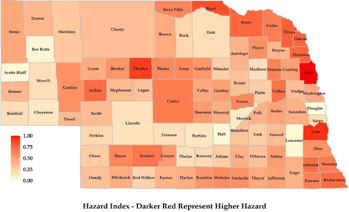
Northern and western parts of Nebraska experience flooding due to heavy rainfall, rapid snowmelt, ice jams, and river overflow. This region is home to many rivers, such as the Platte River, Missouri River, Niobrara River, and Elkhorn River (Fig. 1). The Niobrara River, a tributary of the Missouri River, runs through the Sandhill’s region of Nebraska and eventually joins the Missouri River at Niobrara, Nebraska. Further, the Elkhorn River, the tributary of the Platte River, runs through Antelope County and joins the Platte River near Gretna, Nebraska (part of Sarpy County). Additionally, the region’s topography of rolling hills and steep terrain also significantly exacerbates flash flooding in the region12.
Several counties, including Burt, Boyd, and Cass in the eastern region of Nebraska, showed a higher hazard of riverine flooding (Fig. 5). This can be attributed to the Missouri River, the Platte River, the Elkhorn River, and the Big Blue River, which runs through the eastern counties. Douglas County showed less hazard of property damage since there were fewer properties at hazard relative to the total number of properties, even though it had more properties overall. In the southern region of Nebraska, counties on the eastern front showed a higher flood hazard associated with properties. The higher hazard of property flooding is attributed to the presence of the Republican River, the Big Blue River, and the Platte River, which overflow their banks during periods of heavy precipitation or rapid snowmelt. Flooding in this region is also attributed to existing topography and human activities. Also similar to the northern region, the presence of rolling hills and flat plains, as most of Nebraska’s topography has, increases the chance of flash flooding along with infrastructure development in flood-prone areas. This has significantly altered the natural drainage pattern and increased the likelihood of flooding. Figures 5, 6, 7, 8, 9 were generated using the R-Studio software54.
Exposure index
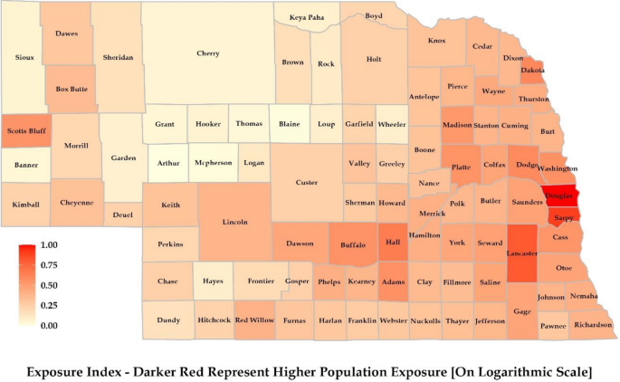
Northern and Western Nebraska had lower population density, which reduced the overall exposure index of the region (Fig. 6). The majority of the population resides in the urban centers of the state, which are mostly located in the eastern part of the state. Douglas and Lancaster counties had the highest population density exposure. Douglas County has the highest population due to the presence of Omaha, the largest city in Nebraska. Lincoln, situated in Lancaster County and the capital of Nebraska, is the second most populated city. The next highest-populated city is Papillion (Sarpy County), followed by Bellevue (Sarpy County), Grand Island (Hall County), and Kearney (Buffalo County).
Vulnerability index
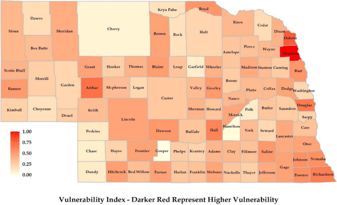
In the context of social vulnerability, in Northern and Western Nebraska, counties like Banner, Scotts Bluff, Sioux, and Sheridan showed higher indexes because these regions had a relatively higher proportion of elderly and infant populations (Fig. 7). Language and cultural differences could be observed in these regions due to a substantial number of Hispanic, African/Black, and Asian individuals. On the ecological front, these regions had better air quality (PM 2.5 concentration was the least for Nebraska’s north and western regions). However, factors like lower food environment index and occupational hazard were higher for Grant and Blaine counties, resulting in a higher ecological vulnerability. This part of Nebraska has higher income inequality and less available housing, which resulted in a higher economic vulnerability index. The higher obese and disabled population also increased health vulnerability.
In Eastern Nebraska, Thurston County was found to have the highest health and economic vulnerability, while Douglas, Lancaster, and Dakota showed higher social vulnerability due to the presence of more diverse ethnic groups. In the context of vulnerability, the southern region containing Furnas, Harlan, Franklin, and Pawnee had a higher elderly population, resulting in a higher social vulnerability index. Similarly, Dawson and Hall counties showed higher indexes due to Hispanic and African/Black populations. The other factors which resulted in higher vulnerability included income inequality, food environment index, and the presence of disabled and obese population.
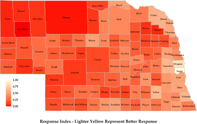
Response index
The northern and western regions’ response was guided by the presence of more wetlands, which reduces the risk of flooding. Further, the fact that these regions experience less flooding compared to Nebraska’s eastern and southern regions makes them safer and reduces the response requirement (Fig. 8). The regions also showed better response because of better emergency preparation for flooding events. It was observed that emergency shelter availability per person was higher for regions like Blaine, Loup, Thomas, and Grant. However, this can be due to the fact they have a lesser population. In the eastern region, counties like Sarpy, Douglas, Saunders, and Lancaster showed better responses. Counties like Douglas, Sarpy, and Lancaster have higher insurance coverage rates for properties. Also, these regions have more structural flood control measures in the form of levees and dams. However, there have been more flooding events compared to other regions of Nebraska, resulting in higher risk. Response to flooding was well addressed in the southern region. There were several factors behind this. Firstly, a substantial number of dams were located in the area, resulting in higher drainage areas. Secondly, these counties have many natural wetlands, which can effectively reduce the risk of flooding. Third, counties like Dundy, Hitchcock, Red Willow, Franklin, and Webster have seen relatively lower flooding in recent times12.
Risk index
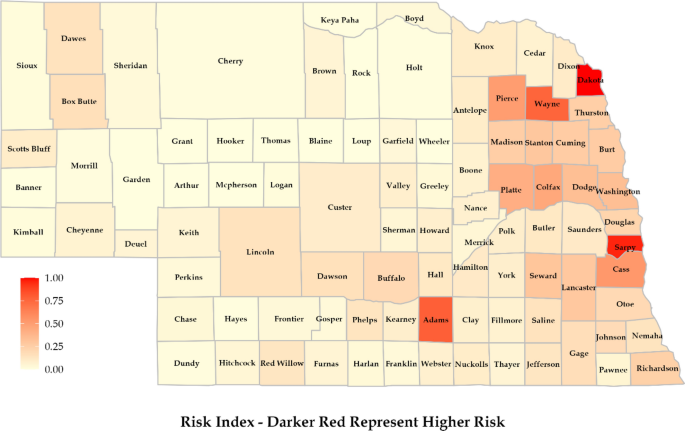
The final risk map showed the overall risk associated with flooding (Fig. 9). This was prepared considering all the drivers (hazard, exposure, vulnerability, and response). Counties located in the eastern part of Nebraska showed higher risk. Dakota and Sarpy showed the highest risk of flooding, while Adams, Wayne, Cass, Pierce, Colfax, and Platte showed a substantial amount of risk. Although counties like Douglas and Lancaster are more densely populated and have a higher density of infrastructures compared to others, they showed relatively lower risk since they have a stronger response capability to flooding. Further, we used the relative value of each variable and scaled them for a better comparative analysis with vastly different population sizes and numbers of housing units. The counties in Western Nebraska showed a lower risk of flooding, which does not imply that no flooding can occur. This part of the state has lower exposure and a less susceptible population, so the chance of severe flooding consequences is reduced. The heightened risk in Dakota County stems primarily from a greater number of properties exposed to hazards, coupled with notable vulnerabilities. Sarpy County’s elevated overall risk, compared to other counties, arises primarily from increased exposure. Additionally, a notable level of vulnerability further elevates the overall risk assessment despite their well-implemented response measures. Also, many counties exhibit varying risk factors across different components. For instance, though Douglas County has more exposure, it has a lower hazard value than other counties such as Adams, Sarpy, Wayne, Cass, Dakota, and Thurston. Overall, these results gave strong insights into flood risk at the county level. They could be a good starting point for other studies to look for flood risk at the county scale while considering an exhaustive list of risk factors.
Introducing response has led to significant changes in the risk map compared to the original risk formulation. Nebraska flood management plan documents the highest frequency of flooding incidents in southeastern counties12. These counties include Richardson, Nemaha, Saline, Saunders, Otoe, and Cass, which have endured the substantial impacts of flooding. However, an examination of their response to these flooding challenges reveals that these counties have implemented effective flood control measures. Collectively, they have established over 350 flood-controlling structures, primarily in the form of dams14. The same proactive approach applies to their utilization of levees, bolstering their preparedness for flood events14. Similarly, counties such as Douglas, Sarpy, Dodge, Lancaster, and Cass have responded by enhancing their property insurance coverage. While the regions in eastern Nebraska remain more susceptible to flooding, these counties have demonstrated noteworthy strategies for mitigating the risk. These types of information are necessary for a more realistic risk assessment. By explicitly considering forms of response, we can gain valuable insights into varying risk profiles, and a better understanding of the overall risk landscape.
Risk index validation
In 2019, Nebraska experienced one of the deadliest flooding events. Out of 93 counties, 81 declared emergencies with a loss of more than 1.3 billion USD in infrastructure damages12. The counties which suffered the most included Adams, Boyd, Buffalo, Colfax, Custer, Dodge, Douglas, Knox, Madison, Nemaha, Pierce, Platte, Richardson, Sarpy, Saunders, Stanton, and Washington. These counties experienced significant damage to population and properties. The loss of infrastructure affected the post-flooding response as it limited access to different areas. Further, these counties were identified as having higher infrastructure damage, crop and livestock losses, evacuations and displaced residents, disruption to services, economic loss, and environmental impacts. Our study also showed substantial risk in most of these areas. However, it should be noted that our analysis focuses on properties and the associated population. The scope can be broadened by adding more information related to economic, environmental, health, and social dimensions.
Uncertainty sources and future developments
We encompassed different dimensions under each component of risk. To quantify risk, we acquired datasets from various sources such as DataUSA, First Street Foundation, Homeless Shelters Organization, State Organizations, U.S. Army Corps of Engineers database, and U.S. Census Bureau. Note that the quality and consistency of these datasets can vary due to discrepancies in definitions, methodologies, and modes of collection. Future developments can look toward improving data sharing and integration capacity, standardizing data collection methodologies, and conducting collaborations at different levels (researchers, policymakers, and stakeholders).
We explored the risk associated with flooding on a county scale for Nebraska using a unique combination of components and variables. Each driver and the corresponding variable used to quantify them were equally weighted. There can be other ways to come up with the weightage; for instance, Reckien used existing documents and assessment reports for weighing indicators55. Bankoff et al. suggested expert knowledge for the selection and weightage of variables56, while Rufat et al. utilized the weights developed by prior studies57. It would be valuable for future studies to weigh each variable according to their importance in estimating flood risk.
We assessed flood risk associated with properties and population, which can be calculated for other dimensions of floods (geographic, social, and infrastructural). It is difficult to quantify flood hazards at a county or state level at a high resolution due to the computation challenges associated with detailed spatial–temporal modeling. In such cases, studies can work toward developing high-resolution flood maps, which can be used for quantification of flood hazards.
We classified county flood vulnerability into four major types: social, ecological, economic, and health. This allowed us to explore different aspects which affect humankind. There is potential for future studies to expand this list of factors resulting in flood-associated vulnerability. Further, in the context of health vulnerability, more publicly accessible data can be beneficial. Information related to different diseases caused by floods can be helpful in establishing essential risk frameworks.
Quantification of flood-risk response was one of the novelties of this work. We classified response into four classes based on the information obtained from the Department of Natural Resources in Nebraska, the Nebraska Department of Health and Human Services, state flood hazard management plans, and the U.S. Army Corps of Engineers website. It will be essential to develop a system to collect and quantify response information associated with flooding.
Conclusion
This study gave insights into the flood risk linked to properties and associated population at a county scale for the state of Nebraska. We quantified flood risk by modifying the existing IPCC's risk framework (with hazard, exposure, and vulnerability) to add a response component. We obtained information about properties at risk of flooding, which constituted our hazard component. Exposure was quantified by including population information in the framework. We split the vulnerability factors into four sub-classes to explore how vulnerability can affect flood risk and preparedness. We quantified response to include different mitigation strategies counties are using to counter flooding. The overall flood risk was mostly concentrated in the eastern part of the state, particularly in Sarpy, Dakota, Adams, Wayne, Cass, Pierce, Platte, and Colfax counties. The methodology implemented in this study is not limited to the quantification of flood risk associated with properties. It can be applied to other dimensions of floods and hazardous events like droughts, forest fires, and cold waves. However, the drivers may need to be modified for different cases and hazardous events. A county-scale approach like this will make policymakers aware of the existing risks and vulnerabilities. This can help make tailored, effective, and locally relevant policies at the county level.
Data availability
The datasets used and analyzed during the current study are available from the corresponding author upon reasonable request.
References
Lal, P. N. et al. National systems for managing the risks from climate extremes and disasters. In Managing the Risks of Extreme Events and Disasters to Advance Climate Change Adaptation Vol. 9781107025 (eds Field, C. B. et al.) 339–392 (Cambridge University Press, 2012).
Cutter, S. L., Mitchell, J. T. & Scott, M. S. Revealing the vulnerability of people and places: A case study of georgetown county, South Carolina. Ann. Assoc. Am. Geogr. 90, 713–737 (2000).
Koks, E. E., Jongman, B., Husby, T. G. & Botzen, W. J. W. Combining hazard, exposure and social vulnerability to provide lessons for flood risk management. Environ. Sci. Policy 47, 42–52 (2015).
Binita, K. C., Shepherd, J. M., King, A. W. & Johnson Gaither, C. Multi-hazard climate risk projections for the United States. Nat. Hazards 105, 1963–1976 (2021).
Simpson, N. P. et al. A framework for complex climate change risk assessment. One Earth 4, 489–501 (2021).
Vojtek, M. & Vojteková, J. Flood hazard and flood risk assessment at the local spatial scale: A case study. Geomat. Nat. Hazards Risk 7, 1973–1992 (2016).
Wood, N. J., Burton, C. G. & Cutter, S. L. Community variations in social vulnerability to Cascadia-related tsunamis in the U.S. Pacific Northwest. Nat. Hazards 52, 369–389 (2010).
First Street Foundation. First street foundation property level flood risk statistics V2.0 (2.0) Zenodo. 10.5281/zenodo.6498206 (2021).
U.S. Census Bureau. Data. census website. Retrieved from https://www.census.gov/data/ (Accessed 11 December 2022) (2020).
Nebraska, NE. DataUSA. Retrieved from https://datausa.io/profile/geo/nebraska (2020).
Nebraska Department of Natural Resources, Dam inventory coverage https://gis.ne.gov/portal/apps/webappviewer/index.html?id=2aab04a13817421992dc5398ad462e22 (2020).
State of Nebraska flood hazard mitigation plan. https://dnr.nebraska.gov/sites/dnr.nebraska.gov/files/doc/floodplain/resources/2022_SFHMP_FINAL_20220630_Ver2.pdf (Accessed 11 December 2022) (2022).
Nebraska Department of Health and Human Service, Emergency medical technician availability at county scale for Nebraska. https://dhhs.ne.gov/Pages/Interoperability.aspx (2020).
U.S. army corps of engineers. “National Levee Database” website. Headquarters, Washington, D.C. https://levees.sec.usace.army.mil/#/ (2020).
Homeless shelter directory. https://www.homelessshelterdirectory.org/state/nebraska (Accessed 11 December 2022) (2022).
Winsemius, H. C. et al. Global drivers of future river flood risk. Nat. Clim. Change 6, 381–385 (2016).
Smith, A. et al. New estimates of flood exposure in developing countries using high-resolution population data. Nat. Commun. 10, 1814 (2019).
Swain, D. L. et al. Increased flood exposure due to climate change and population growth in the United States. Earth’s Future https://doi.org/10.1029/2020EF001778 (2020).
Buchanan, M. K. et al. Sea level rise and coastal flooding threaten affordable housing. Environ. Res. Lett. 15, 124020 (2020).
Zhong, S. et al. The long-term physical and psychological health impacts of flooding: A systematic mapping. Sci. Total Environ. 626, 165–194 (2018).
Flanagan, B. E., Gregory, E. W., Hallisey, E. J., Heitgerd, J. L. & Lewis, B. A social vulnerability index for disaster management. J. Homel. Secur. Emerg. Manag. https://doi.org/10.2202/1547-7355.1792 (2011).
Bateman, J. M. & Edwards, B. Gender and evacuation: A closer look at why women are more likely to evacuate for Hurricanes. Nat. Hazards Rev. 3, 107–117 (2002).
Laska, S. & Morrow, B. H. Social vulnerabilities and Hurricane Katrina: An unnatural disaster in New Orleans. Mar. Technol. Soc. J. 40, 16–26 (2006).
Chang, H. et al. Assessment of urban flood vulnerability using the social-ecological-technological systems framework in six U.S. cities. Sustain. Cities Soc. 68, 102786 (2021).
Scheuer, S., Haase, D. & Meyer, V. Exploring multicriteria flood vulnerability by integrating economic, social and ecological dimensions of flood risk and coping capacity: From a starting point view towards an end point view of vulnerability. Nat. Hazards 58, 731–751 (2011).
Grineski, S., Collins, T. W., Chakraborty, J. & Montgomery, M. Hazardous air pollutants and flooding: A comparative interurban study of environmental injustice. GeoJournal 80, 145–158 (2015).
Rajagopalan, S., Brook, R. D. & Al-Kindi, S. Air pollution and flooding in the lungs: Modern insights into ancient problems. Eur. Heart J. 42, 1592–1594 (2021).
Paterson, D. L., Wright, H. & Harris, P. N. A. Health risks of flood disasters. Clin. Infect. Dis. 67, 1450–1454 (2018).
He, C. et al. The impact of flood and post-flood cleaning on airborne microbiological and particle contamination in residential houses. Environ. Int. 69, 9–17 (2014).
Casimiro, A. C. R. et al. Escapes of non-native fish from flooded aquaculture facilities: The case of Paranapanema River, southern Brazil. Zoologia 35, 1–6 (2018).
Das, B. K. Flood disasters and forest villagers in Sub-Himalayan Bengal. Econ. Polit. Wkly. 44, 71–76 (2009).
Felsenstein, D. & Lichter, M. Social and economic vulnerability of coastal communities to sea-level rise and extreme flooding. Nat. Hazards 71, 463–491 (2014).
Wilkinson, R. G. & Pickett, K. E. Income inequality and social dysfunction. Annu. Rev. Sociol. 35, 493–511 (2009).
Peek-Asa, C., Ramirez, M., Young, T. & Cao, Y. Flood-related work disruption and poor health outcomes among university students. Prehosp. Disaster Med. 27, 503–508 (2012).
Azad, A. K., Hossain, K. M. & Nasreen, M. Flood-induced vulnerabilities and problems encountered by women in northern Bangladesh. Int. J. Disaster Risk Sci. 4, 190–199 (2013).
Xiao, Y. & Feser, E. The unemployment impact of the 1993 U.S. midwest flood: A quasi-experimental structural break point analysis. Environ. Hazards 13, 93–113 (2014).
Penning-Rowsell, E. C. & Priest, S. J. Sharing the burden of increasing flood risk: Who pays for flood insurance and flood risk management in the United Kingdom. Mitig. Adapt. Strateg. Glob. Change 20, 991–1009 (2015).
Noy, I. & Yonson, R. Economic vulnerability and resilience to natural hazards: A survey of concepts and measurements. Sustainability 10, 2850 (2018).
Aroca-Jiménez, E., Bodoque, J. M., García, J. A. & Díez-Herrero, A. A quantitative methodology for the assessment of the regional economic vulnerability to flash floods. J. Hydrol. 565, 386–399 (2018).
Geiling, J. Critical care of the morbidly obese in disaster. Crit. Care Clin. 26, 703–714 (2010).
Gray, L. & MacDonald, C. Morbid obesity in disasters: Bringing the “conspicuously invisible” into focus. Int. J. Environ. Res. Public Health 13, 1029 (2016).
Baggett, J. Florida disasters and chronic disease conditions. Prev. Chronic Dis. 3, A66 (2006).
Feldner, M., Babson, K. & Zvolensky, M. Smoking, traumatic event exposure, and post-traumatic stress: A critical review of the empirical literature☆. Clin. Psychol. Rev. 27, 14–45 (2007).
Leventhal, A. M. & Zvolensky, M. J. Anxiety, depression, and cigarette smoking: A transdiagnostic vulnerability framework to understanding emotion–smoking comorbidity. Psychol. Bull. 141, 176–212 (2015).
North, C. S., Kawasaki, A., Spitznagel, E. L. & Hong, B. A. The course of PTSD, major depression, substance abuse, and somatization after a natural disaster. J. Nerv. Ment. Dis. 192, 823–829 (2004).
Rolfe, M. I. et al. Social vulnerability in a high-risk flood-affected rural region of NSW, Australia. Nat. Hazards 101, 631–650 (2020).
Scherder, E. J. A., Bogen, T., Eggermont, L. H. P., Hamers, J. P. H. & Swaab, D. F. The more physical inactivity, the more agitation in dementia. Int. Psychogeriatr. 22, 1203–1208 (2010).
Stuff, J. E. et al. Household food insecurity is associated with adult health status. J. Nutr. 134, 2330–2335 (2004).
Kleinman, R. E. et al. Hunger in children in the United States: Potential behavioral and emotional correlates. Pediatrics 101, e3–e3 (1998).
Champagne, C. M. et al. Dietary intake in the lower Mississippi delta region: Results from the foods of our delta study. J. Am. Diet. Assoc. 104, 199–207 (2004).
Hamelin, A., Habicht, J. & Beaudry, M. Food insecurity: Consequences for the household and broader social implications. J. Nutr. 129, 525S-528S (1999).
Srivastava, S. The efficacy of conservation practices on reducing floods and improving water quality. Front. Environ. Sci. 11, 10–12 (2023).
Mitsch, W. J. & Gosselink, J. G. The value of wetlands: Importance of scale and landscape setting. Ecol. Econ. 35, 25–33 (2000).
RStudio Team. (2022). RStudio: Integrated Development for R. [Software]. Available at https://rstudio.com.
Reckien, D. What is in an index? Construction method, data metric, and weighting scheme determine the outcome of composite social vulnerability indices in New York City. Reg. Environ. Change 18, 1439–1451 (2018).
Bankoff, G., Frerks, G. & Hilhorst, D. Mapping Vulnerability: Disasters, Development and People (Routledge, 2004). https://doi.org/10.4324/9781849771924.
Rufat, S., Tate, E., Emrich, C. T. & Antolini, F. How valid are social vulnerability models?. Ann. Am. Assoc. Geogr. 109, 1131–1153 (2019).
Funding
This research is supported by the Daugherty Water for Food Global Institute at the University of Nebraska.
Author information
Authors and Affiliations
Contributions
S.S. and T.R. conceptualized the idea. S.S. carried out the analysis and wrote the initial draft of the manuscript. T.R. supervised the work and contributed to reviewing and editing the manuscript. Both authors have approved the submitted version of the manuscript.
Corresponding author
Ethics declarations
Competing interests
The authors declare no competing interests.
Additional information
Publisher's note
Springer Nature remains neutral with regard to jurisdictional claims in published maps and institutional affiliations.
Rights and permissions
Open Access This article is licensed under a Creative Commons Attribution 4.0 International License, which permits use, sharing, adaptation, distribution and reproduction in any medium or format, as long as you give appropriate credit to the original author(s) and the source, provide a link to the Creative Commons licence, and indicate if changes were made. The images or other third party material in this article are included in the article's Creative Commons licence, unless indicated otherwise in a credit line to the material. If material is not included in the article's Creative Commons licence and your intended use is not permitted by statutory regulation or exceeds the permitted use, you will need to obtain permission directly from the copyright holder. To view a copy of this licence, visit http://creativecommons.org/licenses/by/4.0/.
About this article
Cite this article
Srivastava, S., Roy, T. Integrated flood risk assessment of properties and associated population at county scale for Nebraska, USA. Sci Rep 13, 19702 (2023). https://doi.org/10.1038/s41598-023-45827-4
Received:
Accepted:
Published:
DOI: https://doi.org/10.1038/s41598-023-45827-4
This article is cited by
-
Delineation of flood risk terrains and rainfall visualisation in the North Western part of Ghana
Modeling Earth Systems and Environment (2024)
Comments
By submitting a comment you agree to abide by our Terms and Community Guidelines. If you find something abusive or that does not comply with our terms or guidelines please flag it as inappropriate.

