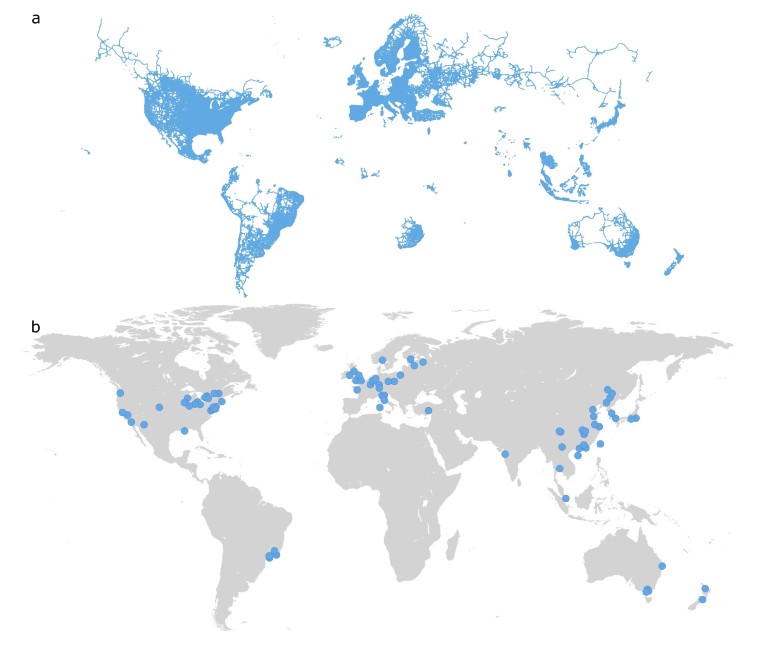
a. Streets mapped with high resolution imagery (obtained by Google Street View). The outlined roads represent street view data publicly available in August 2022. b. The global pattern of applied street view research within urban studies. Europe, North America, and Asia are the continents, where most research has used street view.Mette Bendixen et al 2023
Google street view (GSV) imagery is transforming scientist’s ability to document changes in global landscapes and societies. However, when addressing the development of street view applications today only 20% of African countries have partial coverage of these images, often limited to a few large cities.
This data gap limits the scientific community’s ability to conduct diverse and equitable research within a rapidly growing research field. While alternative mapping platforms such as Mapillary and KartaView exist, they rely heavily on crowdsourced image collection to build data and often result in unequal coverage and poor quality compared to commercial SV data..
Street View images and research
Street view images are a rapidly emerging field in research. They are, for example, helping epidemiology researchers investigate the risk of COVID-19 spread in neighborhoods and other built environments and assessing damage caused by hurricanes. On a global scale, the imagery increasingly serves as big data inputs for machine learning applications for image recognition in data science.
But African countries are largely excluded in the development of street view applications. Literature reviews on health research and urban studies did not find a single case of street view research in Africa.
The coverage of street-level imagery can be viewed as an indicator of local digital infrastructure and technology. Areas with a higher density of commercial activity tend to receive more coverage. The current mapping approach is skewed towards high-income countries.
The few studies using street view images in Africa, focus on larger cities in South Africa. While limited coverage from the world's largest street view platform (GSV) in some countries can be explained by the presence of other services (e.g. Tencent Maps or Baidu), or governments deliberately restricting coverage, the asymmetric representation in Africa is a consequence of implementation strategies, lack of local digital infrastructure and underlying corporate interests.
When limited spatial distribution of street view data is available, an entire research field fails to capture the variation and complexity between individual countries, cities, cultures, and places. AI-based image recognition is sensitive to the baseline data used to calibrate algorithms. Skewed social or spatial representations of such baseline data creates biases when input data is based on higher-income countries, and consequently, research based upon it doesn’t benefit Africa.
Steps to improving coverage
Privacy considerations and compliance with institutional and governmental policies on data rights and access are key to ensuring comprehensive and equitable street mapping coverage in new regions. For example, it took roughly nine months for a team of volunteers to establish a partnership with the government of Zanzibar to initiate the city’s first street view project. Critics against street-scape imagery argue that it undermines privacy, pointing to a need for a broader discussion on the benefits of collecting street-level imagery versus the potential conflicts of surveillance.
