Undisturbed river deltas are diverse ecosystems that encompass tidal wetlands and floodplains. Because of their rich soils and convenient positions for trade and transport, many deltas have also become hotspots of socio-economic development. The Nile delta, for example, with its iconic triangular shape, has been one such locus for more than 5,000 years. Not all deltas are triangular, however — their morphology can vary widely. Writing in Nature, Nienhuis et al.1 report a model that correlates the forces that shape deltas with delta morphology, and use it to analyse the shapes of some 11,000 coastal deltas. This global overview allows the authors to assess how delta morphology is affected by changes in sediment delivery caused by river damming and soil erosion.
Read the paper: Global-scale human impact on delta morphology has led to net land area gain
The authors’ model estimates delta morphology on the basis of a quantitative characterization of three main drivers that shape deltas. These are: sediment delivered by the river; wave action that redistributes sediment along the coast; and sediment transported into or out of the delta by tidal flows. The relative influences of these drivers were used to determine two key morphological metrics; namely, the protrusion of the delta into the sea and the shape of the river channel. For example, Nienhuis et al. infer from the model that when the effects of sediment delivered by the river are greater than the effects of wave action, deltas protrude relatively far into the sea. Alternatively, the authors conclude that deltas widen towards the sea into a trumpet shape when tidal flows are important and sediment delivery is low. Nienhuis et al. validated their model by comparing the projected morphologies with those of real deltas, and provide robust statistics on the reliability of the results, which is a key strength of the study.
Note that the authors’ definition of what constitutes a delta is broad (see the Methods section of the paper for the criteria used), which means that their model is truly global. However, the model’s ability to capture the general behaviour of all deltas comes at the expense of fine-grained accuracy — there will almost inevitably be errors in the morphologies projected for some individual deltas. Nevertheless, the model’s results are statistically valid at a global level.
Nienhuis and colleagues used their model to estimate the effects of upstream human interventions on delta morphology during the period 1985–2015. They found that dam building led to decreases in sediment delivery, whereas accelerated soil erosion caused by deforestation increased sediment delivery. Of the approximately 11,000 deltas analysed, about 9% are significantly affected by reduced sediment delivery, producing a total land loss of 127 square kilometres per year, whereas about 14% received increased sediment, causing a total gain of 181 km2 yr–1 during the study period. The reason more deltas have experienced an increase in sediment delivery, rather than a decrease, is simply that the effects of massive deforestation have outpaced sediment trapping by dams.
A river that flows free connects up in 4D
Previously reported state-of-the-art studies2,3 of global coastal morphology involved the computationally intensive analysis of extremely large archives of satellite images, which have become available in the past few years. These studies also revealed a net increase in land surface area. Many of the land gains could be explained by large-scale phenomena, such as the disappearance of the Aral Sea in central Asia, and by extensive land-reclamation projects along the China coast. But beyond those special cases, it is also crucial to learn in greater detail where and why river deltas have gained or lost land across the globe. Nienhuis et al. fill in this key part of the puzzle.
The new study also reveals notable regional patterns. For example, arctic river deltas have seen almost no change in morphology. Sediment delivery by rivers in North America has fallen overall, leading to large land losses — in the Mississippi delta, for example. And the largest land gains are in eastern South America and in south, southeast and east Asia, where soil erosion due to deforestation has caused a net growth in delta areas, despite the construction of sizeable dams in these regions.
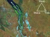
Large deltas, such as those of the Niger, Huang He and Mekong, have great socio-economic value. Such densely inhabited deltas typically experience many pressures in addition to changes in sediment delivery, such as stresses associated with groundwater pumping, sand mining, dyke construction and loss of biodiversity4–6. For these highly complex deltaic systems, local studies will be needed to assess the problems that adversely affect their morphology and to define specific solutions6. However, most of the deltas considered by Nienhuis and co-workers are much smaller. This could skew the picture painted by the overall numerical results, because large deltas have a much greater global impact than do small ones, but represent a tiny fraction of the total number of deltas analysed in the study. For example, the study calculates that the net land gain for all deltas was 54 km2 yr–1 during the period studied, which seems like good news. But this area is tiny compared with the 105,000 km2 covered by the Ganges delta alone (Fig. 1) — which, with its population of 170 million people, is subject to a multitude of stresses7. We should therefore not be complacent about the new findings.

Figure 1 | The Ganges river delta.Credit: Alamy
Nienhuis et al. did not include sea-level rise in their model, but sea levels rose by about 10 cm over the period studied (see go.nature.com/2tpjpxg). This will probably not have produced observable losses of delta land, given the large spatial variability of sea-level rises. Nevertheless, it would be interesting to see whether measurable losses did occur. The authors’ model provides a useful description of the background dynamics of changes in delta morphology against which the impact of rising seas can be measured once sea levels approach predicted increases of 60 cm8 or more9, as a result of global warming. Severe sea-level rise will undoubtedly cause coastline recession in deltas, as it has in the geological past10.
Validated global models describing key parts of the Earth system are crucial in this time of unprecedented human-induced climate change. Deltas connect the terrestrial and maritime branches of the hydrological cycle and the associated sediment fluxes. As such, they encapsulate many key indicators of global change. By accounting for the baseline effects on deltas of human activities such as dam building and deforestation, Nienhuis and colleagues have provided a fundamental framework that will help assessments of the impacts of climate change for decades to come.
 Read the paper: Global-scale human impact on delta morphology has led to net land area gain
 The dynamics of Earth’s surface water
 A river that flows free connects up in 4D