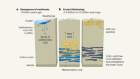
The Red Pyramid, the largest of the pyramids at the Dahshur necropolis, was built more than 4,500 years ago.Credit: Eman Ghoneim
Stretching beneath the ground near the Giza pyramid complex in Egypt lie the remains of an ancient branch of the Nile River that might once have helped ancient Egyptians to build their monuments.
The highest concentration of pyramids in Egypt can be found in a stretch of desert between Giza and the village of Lisht. These sites are now several dozens of kilometres away from the Nile River. But Egyptologists have long suspected that the Nile might once have been closer to that stretch than it is today.
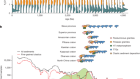
Satellite images and geological data now confirm that a tributary of the Nile — which researchers have named the Ahramat Branch — used to run near many of the major sites in the region several thousand years ago. The discovery, reported on 16 May in Communications Earth and Environment1, could help to explain why ancient Egyptians chose this area to build the pyramids (see ‘Ancient river’).

Source: Ref. 1 Image source: NASA Visible Earth
“The pyramids seem like pretty monumental work,” says Judith Bunbury, a geoarchaeologist at the University of Cambridge, UK. “But it’s less arduous if you can bring big stones up by boat rather than carrying them over land.”
Wandering waterways
For thousands of years, the Nile and its flood-plain have provided food, agriculture and water to Egypt’s inhabitants. The majority of the country’s population still lives in the Nile basin.
But the river is prone to migrating, and in the past, populations have had to relocate to keep up. Over the past few hundred years, the Nile has moved several kilometres to the east, possibly owing to shifting plate tectonics.
There is evidence that some of Egypt’s important archaeological sites do not have the same relationship to the river as they would have had at the time that they were built. There are remains of harbours and other such clues at sites between Giza and Lisht. But scientists have found it difficult to chart the scope or locations of these lost waterways.
While looking for traces of ancient water, a team led by Eman Ghoneim, a geomorphologist at the University of North Carolina at Wilmington, spotted what looked like a dried-up river channel several kilometres west of the Nile. The channel ran for around 60 kilometres through agricultural areas and had a similar depth and width to the modern Nile.

The research team prepares to analyse soil samples collected from an area in the Nile Valley close to the pyramids.Credit: Eman Ghoneim
To investigate whether the channel could be part of an ancient river bed, the researchers collected core samples of sediment from the channel. Beneath the wet mud of the fields, they found an layer of gravel and sand consistent with that of a river bed. Combining these sample data with satellite imagery allowed the team to map the branch’s location. They found that it would have flowed past more than 30 Old- and Middle-Kingdom pyramids dating from between 2686 to 1649 bc — thus the decision to called it the ‘Ahramat’ branch, using the Arabic word for pyramid.
The Ahramat “connected all these different pyramid fields”, says Suzanne Onstine, an egyptologist at the University of Memphis in Tennessee. “Their valley temples and causeways all oriented exactly to where the water would have been.”
Riverside sites
Researchers have long debated the significance of the pyramids’ locations. The waterway running right past them could have been an important factor, because it would have provided a convenient way for builders to transport materials to the sites.
This theory aligns with documents from the era which state that building materials were brought in by boat, says Bunbury.
Eventually, the movement of the Nile and sand blowing in from the Sahara Desert would have caused the Ahramat Branch to dry up and become unnavigable. Today, only a few stray lakes and channels remain where the major branch once ran.
But knowing the ancient river’s location provides a blueprint that archaeologists can use to try to uncover more ancient Egyptian settlements, says Onstine. And the finding that Egyptians were probably using boats rather than land transportation to move materials to build the pyramids hints that they were “a lot more pragmatic than perhaps we realized before”, says Bunbury.
 From the depths: Egypt's lost cities
 The wonder of the pyramids
 The surprising chemicals used to embalm Egyptian mummies
 Lasers reveal ancient pyramids and canals hidden in the Amazon
 Gigantic Nile dam prompts clash between Egypt and Ethiopia